产品展示
信息图
界面稿
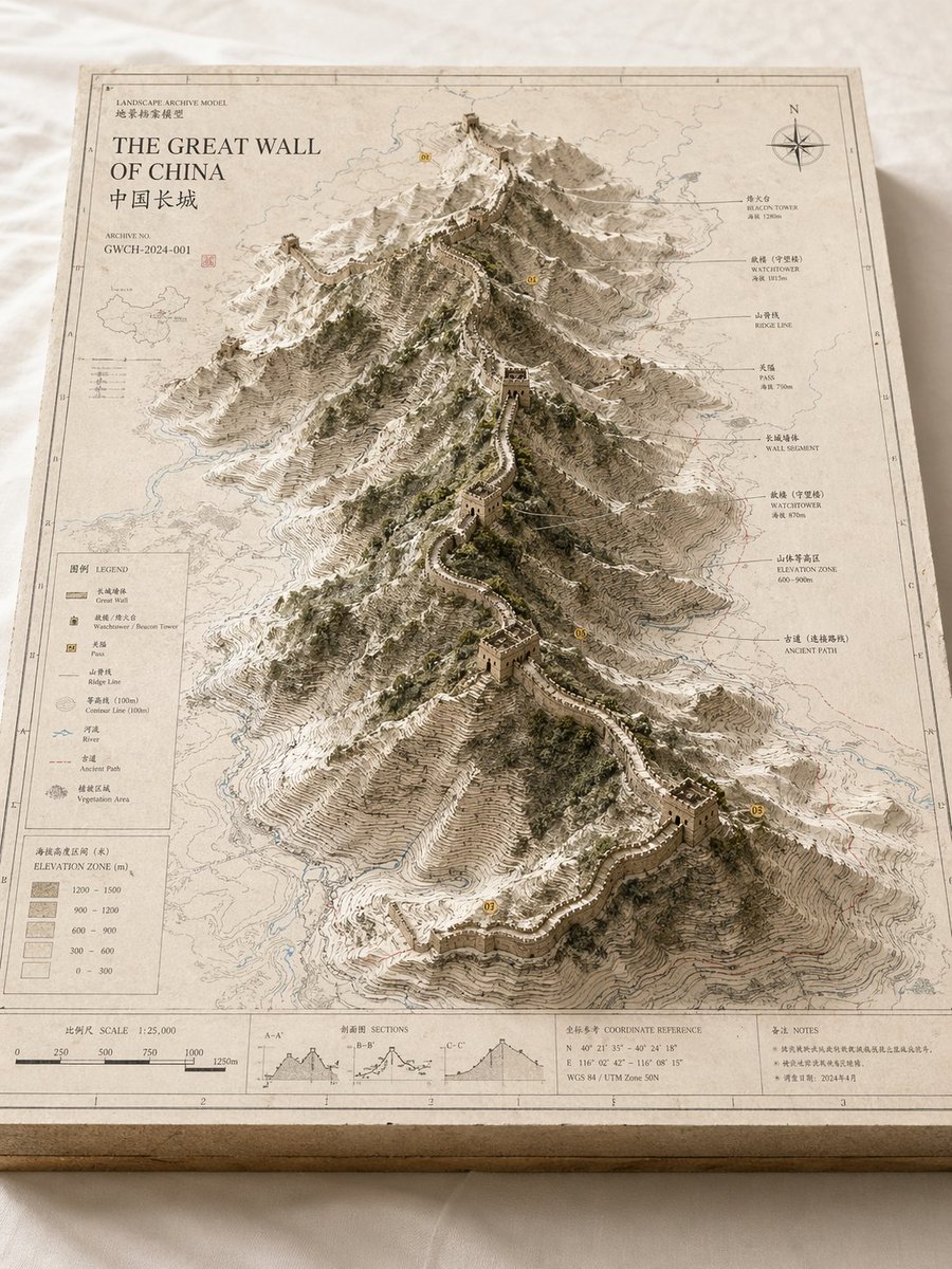
产品视觉 GPT Image 2 提示词:Landscape Archive Model Template
A comprehensive template for creating professional, museum-style 'landscape archive models' that combine 2D maps with 3D terrain and professional annotations.
📝 提示词
Please create a high-quality, professional 'Landscape Archive Model' visual based on {argument name="subject" default="The Great Wall / Mt. Everest / The Bund / Pearl River"} suitable for a series.
This is not a regular map or simple landscape illustration, but a high-end archival visual combining '2D map drafting + 3D regional model + professional annotation system + museum exhibition feel'. The image should look like a real physical geography research model, urban planning sandbox, architectural proposal model, or world-building exhibit, with a professional, restrained, precise, and tactile premium texture.
[Basic Settings]
Subject: {argument name="subject content" default="Crater Lake / Guangzhou / Chongqing"}
Subject Type: [Natural Terrain / Urban Space / Mixed Landscape]
Core Subject: [Core subject, e.g., crater, canyon, mountain range, lake, CBD, old town, landmark group, island city, ruins, main urban area]
Content Focus: [Content focus, e.g., terrain elevation / urban landmarks / road network / hydrology / nature-city relationship / setting collection display]
Style: {argument name="style" default="geographic surveying style, paper-cut model style, architectural proposal style, museum archival style, urban planning style"}
Primary Color: [Primary color, e.g., off-white, light gray, parchment white, sand, snow white]
Secondary Color: [Secondary color, e.g., earth brown, rock gray, cool gray, light blue, moss green]
Accent Color: [Accent color, e.g., thin black lines, red routes, blue hydrographic lines, yellow numbered markers]
Aspect Ratio: [Aspect ratio, e.g., 16:9 landscape / 3:4 portrait / 4:5 portrait / 1:1 square]
[Composition]
The main subject is a rectangular map model board placed on a clean tabletop or white cloth. The base plate has real thickness with visible section structures on the edges, like a refined map slice or model base. The map surface is covered with a clear but restrained information layer, including contour lines, road networks, hydrology, zonal boundaries, geographical textures, a sense of coordinates, slight annotations, and drawing borders.
In the center or off-center area, a 3D model 'grows' out of the 2D map, becoming the visual core of the entire image.
If [Subject Type] is Natural Terrain: The subject consists of mountains, canyons, craters, lakes, basins, islands, glaciers, faults, or coastlines, emphasizing elevation, layered contour structures, rock wall textures, and natural terrain undulations.
If [Subject Type] is Urban Space: The subject consists of the core urban area, CBD, old town blocks, landmark clusters, waterfronts, road nodes, bridges, water systems, or parks, emphasizing architectural massing, urban identity, spatial layers, and planning structure.
If [Subject Type] is Mixed Landscape: It integrates both natural terrain and man-made environments, such as mountain cities, island cities, ancient ruins, apocalyptic wastelands, fantasy capitals, or sci-fi bases.
[Detail Requirements]
- Surface retains map paper and professional information feel.
- Terrain areas should have contours, slope layers, and depressions.
- Architectural areas should have massing, block relationships, and clear hierarchy.
- Water bodies use low-saturation light blue.
- Greenery/forests use moss green or low-saturation green.
- Road networks use fine lines without being distracting.
- Landmarks should be clearly identifiable.
- Sci-fi/fantasy elements should retain the archival model feel rather than appearing as pure scene illustrations.
[Annotation System]
The map board edge needs complete and restrained annotation modules, including frame lines, scales, legend areas, title areas, archive numbers, index marks, note tags, and simple symbol keys. Text doesn't need to be fully legible but must present a realistic, clear, precise, and orderly archival layout.
[Camera & Lighting]
Use an oblique top-down isometric or sandbox composition, with the camera at about 30 to 45 degrees, showing the map plane, model height, edge thickness, and annotation area. Lighting should be soft and natural with delicate real shadows on a clean background, avoiding a cartoonish or cheap game UI look.
🎯 适合场景
适合快速搭建产品图、包装展示和品牌海报:主体、材质、背景与商业修图方向已经有框架,换掉变量就能开跑。
💡 改写建议
- 先替换变量里的品类、人物、城市、品牌色,不急着改整段结构。 把主体、构图和风格分开写,后续微调会更稳。